of accuracy of remote sensing, we will be
able, in some areas, to use the data from
the receiving station.
Space technology came to Zimbabwe
years back, but – like many developing
countries – it has not been able to fully
utilize it. This mainly because of the lack
of knowledge about its importance and
capacity to use it, lack of equipment
as well as possibility to use it within
the government, the main monitor of
agricultural production in Zimbabwe.
Attempts to introduce use of this
technology into government have been
done by some partners such as the
United Nations Development Program
but, because of lack of equipment and
skill, very few departments are using
the technology. As a result, the country
is lagging behind and mostly finds itself
affected by disaster which it would have
avoided by using new tools.
Space technology not onlymakes it easier
to monitor activities like agriculture,
climate change and drought, it can also
be used for timely planning which is
needed in most disaster-prone areas.
The need for competent staff
Zimbabwe
largely
depends
on
agriculture, which is very sensitive
to environmental variations. Satellite
technology can not only improve its
management but alsohelp to faceclimate
change consequences. Sustainability
of agriculture in Zimbabwe means
sustainable livelihoods for the people.
One of the reasons why poverty has
been a thorn in the flesh for the country
is because sustainable development
has been lagging behind. Zimbabwe is
striving for sustainable development
but needs competent staff for capacity
building in new technology as well as
initiatives for acquiring equipment.
Response to many shocks and hazards
depends, to some extent, on sustainable
development. Hence commitment of the
country to support it is a key issue.
c
Rutendo Nhongonhema
Ministry of Agriculture
Harare, Zimbabwe
i
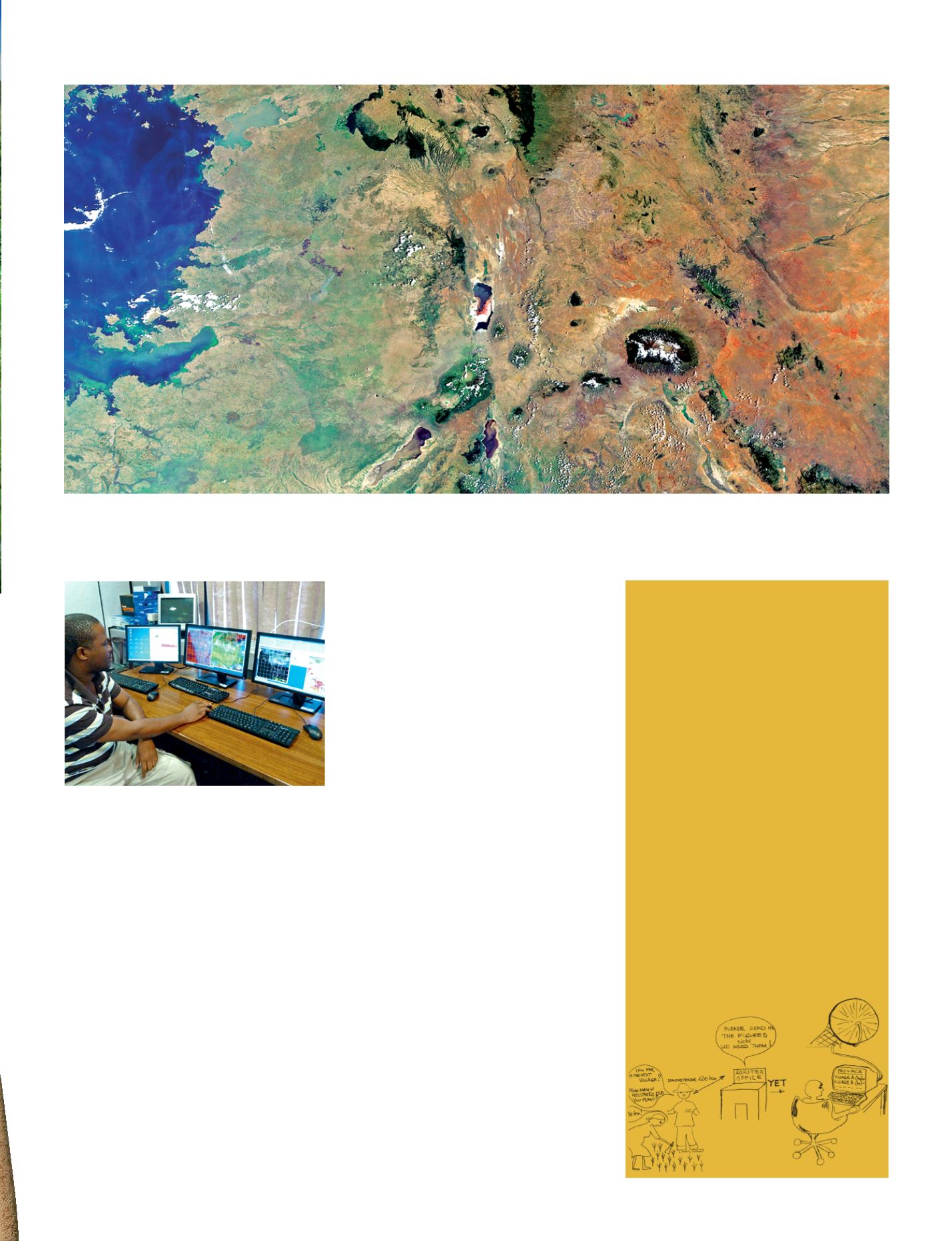
The main objective of GEOGLAM, the GEO Global Agricultural Monitoring initiative, is to strengthen the international Community’s capacity to produce and
disseminate accurate and timely information on agricultural production at national, regional and global scales, with a dedicated component for countries/
regions at production risk. Melting of the Kilimandjaro glacier, Africa’s highest mountain (5895 m) pictured lower-right on this Envisat image, will for example
affect agriculture in Tanzania, Kenya and Uganda. © ESA
Data collection
At thesignof abadseason, policymakers
would want to know the situation in the
whole country. The extension worker is
asked to provide the data for example
areasaffectedbymidseasondrought ina
very short time. They have towalk across
their whole area, sometimes 70kmwide,
in seven days asking farmers which
area they planted is affected by drought.
Now the AMESD station will help the
Head Office in mapping indicative areas
affected. Then the extension worker
might walk the distance at her own pace,
collecting other data like cropped areas
and yield estimation.
Sheilla Bauren
Extension specialist, AGRITEX
Harare, Zimbabwe
i
Selecting data from the AMESD station at the
Botswana College of Agriculture.
© Telespazio
Space Tools - 39


