In spite of these efforts, the reality of
the field shows how far there is to go.
Although regional research centres are
improving the integration of spatial data,
we are still far fromachieving generalised
access to national specialised research
centres and university laboratories.
However, applied research comes up
against limits for want of this information
that can fill gaps resulting from lack of
infrastructure. This is the case of many
crops in Africa and especially for cacao
in Ivory Coast
Researchers will not have all the local
agro-pedo-climatic data defining each
production area. They will therefore be
unable to master the entire evolution
of local biodiversity, a key element for
understanding the agro-ecosystems on
which new agricultural techniques are
based.
Research and food security
Another challenge is that of passing on
knowledge to farmers and supervising
them. It is essential to incorporate these
needs in the strategies developed. For
Ivory Coast this means the maintaining
of its position as the world’s leading
cacao producer, involving a resource
that provides income for a third of the
population of the country.
These considerations also apply for staples
(yam, millet, etc.) to achieve bettermastery
of the evolution of factors of production
and crop forecasting capability.
Many
African
countries
possess
excellent human resources in remote
sensing
and
scientific
research.
However, an increasing population and
environmental stress factors make it
urgent to strengthen the use of spatial
applications and give access to them to
those involved in applied research. The
development of research programmes
focused on the needs of farmers requires
the enrichment of the environmental
data bases held by the programmes.
Promoting environmental scientific
research is essential for perfecting
agro-pedo-climatic knowledge about
production regions and for determining
appropriate
crop
management
sequences. This cannot be done
without the gaining of awareness by
political decision makers so that their
researchers possess tools that will
turn food insecurity into a development
opportunity.
c
Cédric Lombardo
Associate Director
Bedevelopment Consulting
Abidjan, Ivory Coast
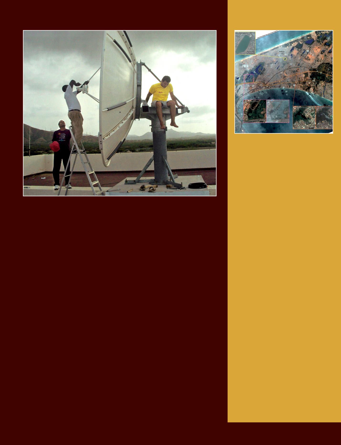
i
Installation of the AMESD station on the premises of INDP (Instituto Nacional de Desenvolvimento das
Pescas) in Cape Verde in October 2010. The main theme is fisheries monitoring.
© Telespazio
Satellite data
and disasters
The International Charter Space and
Major Disasters aims at providing a unified
system of space data acquisition and
delivery to those affected by natural or
man-made disasters through Authorized
Users and thus is helping to mitigate the
effects of disasters on human life and
property. The Charter mobilizes agencies
around the world (among which CNES and
ESA), benefit from their know-how and
their satellites through a single access
point that operates 24 hours a day, 7 days
a week, at no cost for the user.
For example, in August 2013, due to
flooding in Dakar caused by heavy rains,
the International Charter was activated to
support Senegal with its flood response
efforts (see image). Then, inNovember 2013
due to typhoon Haiyan in the Phillippines.
GEO has been collaborating with the
Charter since 2009 with a focus on disaster
management users in GEO Member
States. This collaboration concentrated
on user awareness and methods to
improve broader access to the Charter.
For example, GEO was instrumental in
fostering the approval of the principle of
Universal Access by Charter Members. Any
national disaster management authority
will now be able to submit requests to
the Charter for emergency response.
Proper procedures will naturally have to be
followed, but the affected country will not
have to be a Charter member.
i
This Charter crisis cartographic product shows
the flood situation in Dakar (Senegal) on the 28
th
of
August 2013, as observed from Pléiades-HR1B ima-
gery. This CNES satellite is equiped with an optical
instrument manufactured by Thales Alenia Space.
© CNES 2013 - Distribution Astrium Services / Spot Image
S.A., SERTIT, all rights reserved. Map produced by SERTIT.
Space Tools - 37


