44 - Sustainable Development in Africa & Satellites
data also form the basis for all planning,
sizing and management of hydraulic
infrastructure. The monitoring of water
levels is particularly essential for water
traffic, especially during low-water
periods.
Only about 20 gauging stations are
operational out of the hundreds that
have been installed in the basin. This
results in particular from the years of
political instability and conflicts in the
sub-region and the lack of maintenance
by the national managers of the stations.
The countries of the region are also
experiencing difficulties in the gathering
and dissemination of hydrological
information as entry, processing and
archiving systems are unsuitable or
nonexistent. The other major difficulties
concern technological inadequacies,
especially in the telecommunications
network, and weaknesses in regional
cooperation with regard to the exchange
of data.
The technical and scientific issues are
considerable. In 2002, ESA launched the
TIGER initiative to make a contribution
to a recommendation of the World
Summit on Sustainable Development.
The aim was to help African countries
to gather, analyse and disseminate
geo-information on water using earth-
observing technology. This compensates
for the weakness of
in situ
data
collection infrastructure, making close
management of resources possible.
TIGER could also provide a homogeneous
overview of large regions, making it
easier to integrate local information at
the national level and at the transfrontier
scale, including remote, inaccessible
and somewhat unsafe zones.
Spatial altimetry data
In addition to the TIGER initiative, the
countries of central Africa participate
in the AMESD programme via the
water resources management theme.
Two operational services can thus be
developed by the CICOS, entrusted with
the development of a low water warning
system for river traffic on the Oubangui
and the monitoring of the hydrological
cycle of the Oubangui sub-basin and the
water body in the forest in the ‘Central
Basin’. Implementation involves the use
of spatial altimetry data from ENVISAT
and JASON-2 missions through a
collaboration with IRD and Brazil (ANA).
Development of their use will first be
focused on the Oubangui, one of the
main tributaries of the river Congo
whose vulnerability to climatic variability
is the most marked of the basin. These
operational services could be used by
numerous players in inland waterways,
the environment, development, planning
and hydroelectricity.
Here, it is essential to establish large-
scale hydraulic infrastructure while
taking the downstream effects into
account. Any development operation
has interactive effects at different points
in the basin, most of which is currently
undeveloped. The various countries thus
have the following duties:
• optimising the choice of hydraulic
equipments at the scale of the basin as
a whole,
• assessing the cumulated impacts of
these equipments, especially as regards
transfrontier projects,
• taking into account the conceivable
impacts of climate change.
Allowing for these constraints into
account is essential in the use of our
water resources.
c
Dr Georges Gulemvuga
Director of Water Resources
International Commission for Congo-
Ubangui-Sangha Basin, Kinshasa/ Gombe
The Democratic Republic of the Congo
i
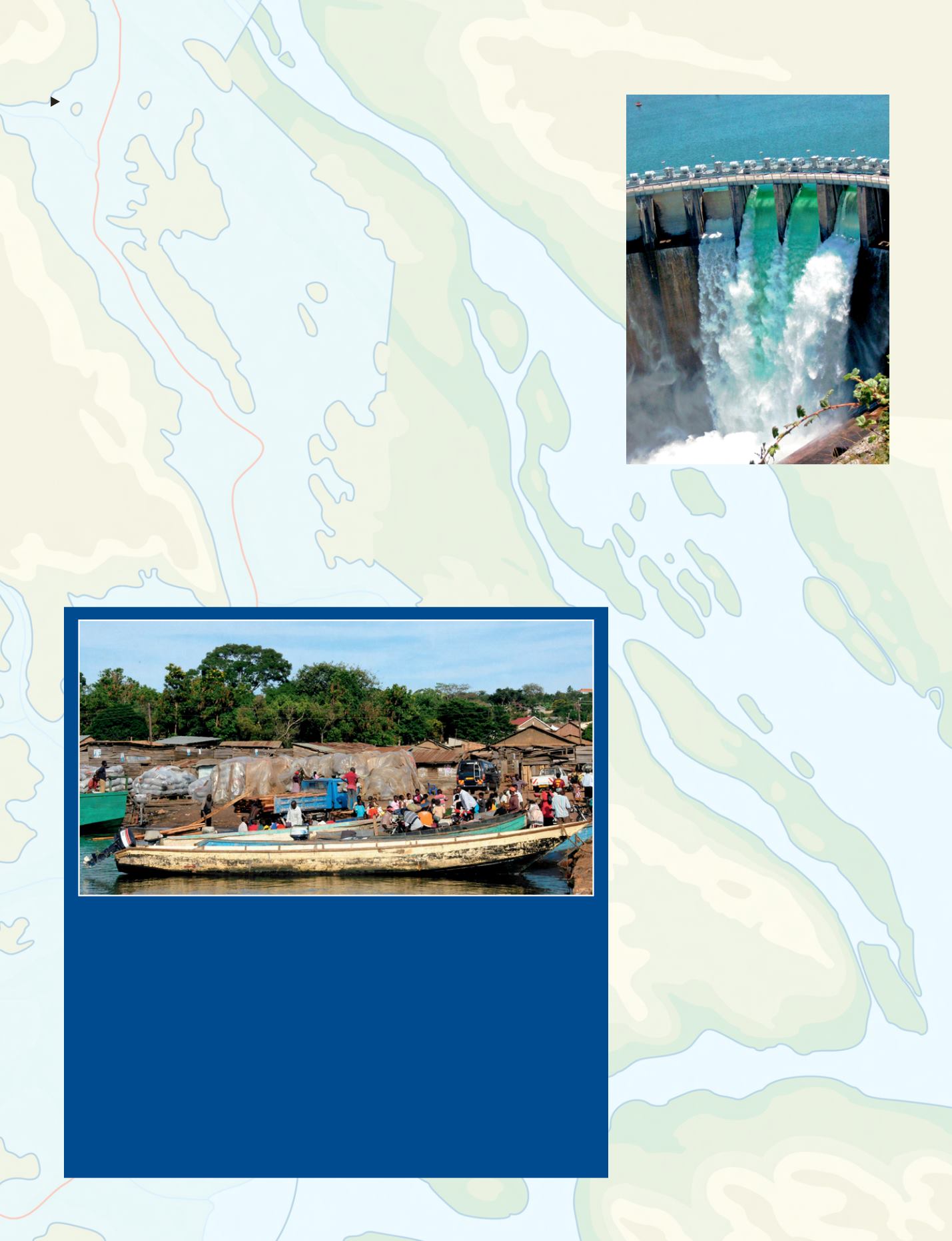
The Inga Dams (DRC). Inga I and II operate at
low output and there are plans for Inga III and
Grand Inga. With only 3% of capacity installed, Inga
dams are considered as ‘‘white elephants’’.
© All rights reserved
Water route prospects
T
he Congo basin has 25000 kilometres of navigable waterways. Within the
framework of its spatial development, river navigation is a very dynamic
component of the industrial transport of heavy loads and bulk goods in general.
With the implementation of the sustainable growth and development approach to
the Congo Basin-Atlantic Ocean corridor, the waterway route has great prospects,
with the development of special economic zones, the enhancement of inter-bank
and interregional trade and the free movement of goods and persons, forming true
catalysts of sustainable development.
Photo © Jean-Michel Citeau/BRLi
Colonel Benjamin Ndala
The Republic of the Congo
Former General Secretary of CICOS


