i
The coastal lake of Manzalah. The largest delta lake in Egypt has been undergoing continuous and pronounced changes since long times.
Image taken by EgyptSat-1 in 2009. © National Authority for Remote Sensing and Space Sciences (NARSS), Egypt.
G
overnments all over the world pay
more and more attention to water
resources because these either
become increasingly scarce or they are
a threat due to flooding. At the same
time there is a growing awareness that
the quality of water resources should
be protected. Water of good quality
and without risks for public health is
nowadays considered to be a major asset.
In Egypt, being an arid country with hardly
any rainfall, water management is of
particular importance. Without a proper
management, water will become a
constraining factor in the socio-economic
development of the country.
Egypt’s Northern lakes support substantial
fisheries and aquaculture activities are
deeply concerned. The water quality is
affected by agricultural drainage water,
containing salts, nutrients, pesticides,
herbicides, and industrial and municipal
effluents from all towns and villages
that drain either directly or indirectly into
the lakes. In response to the increase in
nutrients loading and freshwater inputs, the
fish community in Lake Manzalah has been
transferred from a brackish (mixed species)
to a fresh water (Tilapia) dominated fishery.
In 2005, the project ‘Satellite Monitoring of
Lake Water Quality in Egypt’ was funded
under the international TIGER initiative
with the objective to design, develop and
implement anEarthObservation (EO)-based
capacity for the operational monitoring of
water quality in Lake Manzalah.
Adequate water management
The procedures currently in place rely on
the collection of in-situ measurements
at drainage channels leading into the
lake once per month. However, this field-
based approach does not adequately
capture the spatial and temporal
variability of water quality parameters in
the highly dynamic lake ecosystems.
Key to the formulation of adequate water
management scenarios is accurate and
reliable information on the occurrence and
distribution of water quality indicators,
such as turbidity, algal blooms or areas
infested with invasive plant species.
In particular, water quality information is
required to answer the following questions:
• Where does the pollution come from?
Which areas are affected by it?
• What actions can be taken to mitigate the
problem (e.g., allocation of buffer zones)?
• What is the status of the problem
(increase, decrease, no change)?
• To what degree has an improvement
occurred?
Incorporating EO-derived information
into the existing water quality monitoring
program is expected to have a positive
impact on themanagement and sustainable
use of water resources in Egypt in the long
term by providing a consistent, accurate
record of the spatial and temporal variability
of critical water quality parameters.
In-situ observations are provided by real-
time water quality (RTWQ) probes for the
followingparameters: specific conductance,
Water quality survey
i
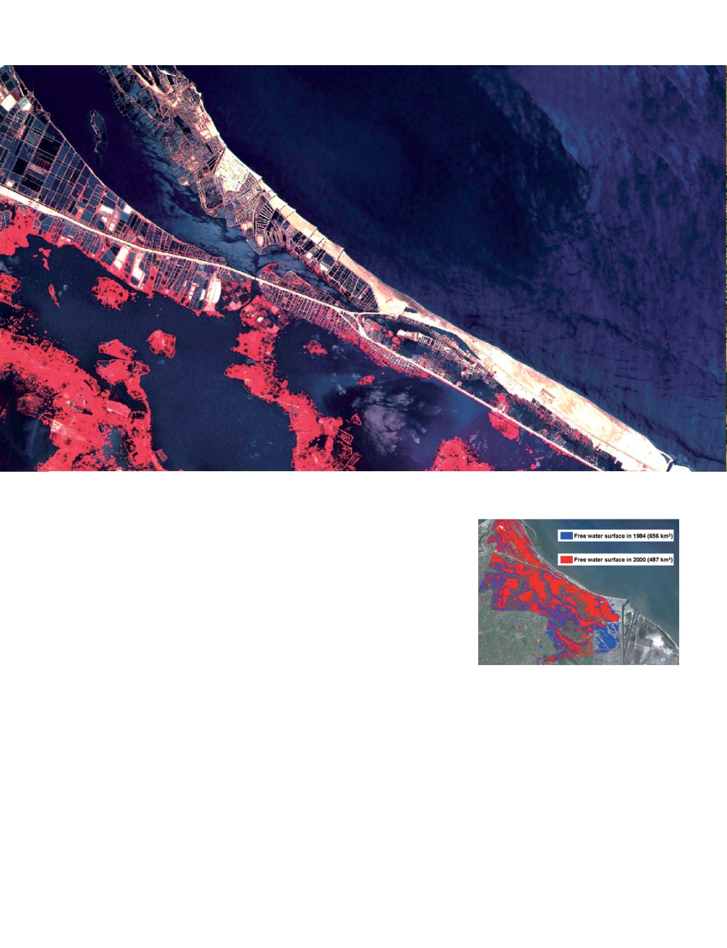
Impact of land reclamation on Lake Manzalah.
Data map courtesy of Akram M. Elganzori.
50 - Sustainable Development in Africa & Satellites


