Coasts and altimetry
88 - Sustainable Development in Africa & Satellites
T
he African continent is bounded by oceanographic regions
internationally recognised as requiring detailed analysis and
monitoring. These are regions of wind-induced upwelling
with high marine productivity and biodiversity called Large Marine
Ecosystems (LMEs- Guinea, Angola and city/state of Benguela).
The global climate is changing at an unprecedented rate,
affecting economies and hence the
livelihoods of people through the
increase of natural disasters such
as droughts, floods, coastal surges,
sea level rise aswell as the sinking of
islands. According to the World Bank
Report on sea level rise and ocean
surges in 2009, many African countries
would be recording an increase in
storminess. Coastal agriculture in
Nigeria (area of 1365 km
2
), might be
totally swept away, while Ghana would
lose about 67% of her 268 km
2
wetlands.
Coastal zones carry over 50% of Africa’s
populationaswellastheindustrialsectors,
with coastal population increasing every
year. For example, Lagos, could soon reach
20million inhabitants.Oil andgasproduction
in the Gulf of Guinea is increasingly offshore,
and storm surges could affect the installations
such as the offshore rigs and subsurface
pipelines.
The region of Cape Agulhas (South Africa), a very
important shipping route linking the countries
bordering Indian Ocean and those in the west,
is subject to the threats of ‘killer waves’ resulting
from the strong westerly winds forcing large waves
against strong opposing current, and may measure
more than twice the size of normal large waves. These
waves also destroy the coastlines. The environmental
agencies and research institutions of coastal countries in Africa
(like NIOMR Nigerian Institute of Oceanography and Marine
Research) have studied sea level change for many decades
using tide gauges within the GLObal Sea level observing System
(GLOSS) data network.
Other measurements of oceanographic features include ship
transects and moorings that sample the ocean to various depths.
But suchmeasurementspresent limitations in termsof spaceand
time coverage and there is no continued data flow over decades.
Due to this unreliability as well as poor coverage, use of satellite
altimeter data becomes necessary, like the ones provided by the
JASON and SARAL missions. It provides a synoptic view of the
ocean and lands with unprecedented accuracy and repeatability.
This essential data is indispensable for decision makers to use
in helping not only to mitigate risks at the densely populated
coastlines but also to aid in the development of infrastructure
that supports life.
For example, major offshore oil and gas companies use satellite
altimeter gravity data to locate offshore sedimentary basins. In
combination with other survey data, this helps them to know
exactly where they will acquire or purchase seismic data.
To encourage the use of satellite resources in exploring the
environment, the African Association of Remote Sensing of the
Environment (AARSE) has very wide objectives that also include
t
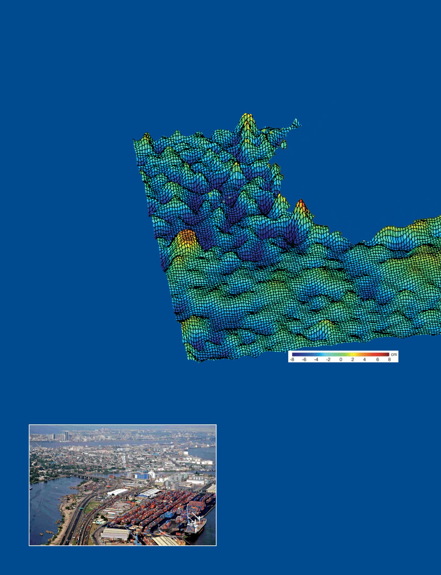
Sea Surface Height Anomaly (SSHA)
taken offshore Nigeria in the Gulf of
Guinea (25-31 March 2009) in cm,
compared to the geoid. The troughs
(negative) and crests (positive) are
deviations from the mean sea level.
The map is produced from data using
altimeter products of Topex/Poseidon,
Jason 1 and 2 and Envisat.
Altimeter products issued by SSALTO/
DUACS, distributed by AVISO with support
from CNES.
o
With a population of 20 million, metropolitan Lagos (Nigeria) is growing rapidly
and the urban poor population living in its coastal areas are at risk in front of
climate change and sea level rise.
© Afritramp


