A
pproximately 600 people die and
over 4 000 are injured annually in
South Africa as a result of fire, and
these blazes cause more than 50 million
Euros’ worth of damage to property
every year. Fire is responsible for many
diseases related to constant smoke, like
asthma. It also has an impact on climate
change, land cover, the productivity of the
vegetation and it opens up the landscape.
When you fly a plane or you look at
satellite images you can see a river of
smoke coming from Angola, flowing over
Zambia, Botswana and Mozambique. It
stays all the year and can reach Australia.
A dramatic event convinced me to devote
my career to fire. In September 2001 a
very big fire disaster killed 23 people in
the Kruger Park. At that time we received
NOAA satellite data. As I had to write the
final report on this event, I mapped this
data and could clearly see where the
fire started, when it crossed the road,
the change in wind direction that killed
people miles away from where it started.
I understood that we could prevent this
kind of disaster if we had a more pro-
active information system, integrating
more data sources.
So in 2003 we started developing the
Advanced Fire Information System
(AFIS) as a service module of the Wide
Area Monitoring Information System.
WAMIS provides continuous data streams
captured and processed by the South
African National Space Agency (SANSA
formerly CSIR — Satellite Application
Centre) at Hartebeesthoek, near Pretoria,
as well as by the Meraka Institute in
Pretoria. It aims to deliver fire information
products to researchers, Fire Protection
Agencies and Disaster managers all over
Southern Africa in support of decision-
making in the monitoring of fires. It is the
first near real time operational satellite
fire monitoring system in Southern
Africa. We were looking for financing and
heard that Eskom, South Africa’s biggest
power company, had problems with fire
developing underneath their 28 000 km
of transmission lines. The smoke ionises
the air, creating a path through which
electricity arcs to the ground. Wild land
fires can then cause flashovers, which
severely affect electricity supply to
industries, causing important economic
losses. We told Eskom: ‘we can prove to
you that we can do something and we will
do it free for a start’.
The architecture of the system was
originally based on the MODIS Rapid
Response Web. But MODIS (Moderate
Resolution Imaging Spectro Radiometer)
only flies over for fifteen minutes twice a
day. So it may miss many. So we decided
to integrate data from METEOSAT Second
Generation (MSG), which provided data
every 15 minutes. At first, people were
sceptical. But the CSIR SAC (Satellite
Application Centre) in collaboration
with David Taylor developed the MSG
Fire Tracker software package and it
worked perfectly: over the next year,
the alert system detected 65% of all
fires that caused outages. So Eskom
agreed to assure the main funding for
the development and implementation of
AFIS.
Technically, one of the problems to solve
is the difficulty to give access to the data
online via Internet.
EUMETCast receiving station
So we look for an alternative system
using EUMETCast, the dissemination
mechanism for the EUMETSAT satellite.
South Africa has about 20 receiving
stations. We produce data and send
it through Internet to EUMETSAT in
Darmstadt (Germany), they send it to
the satellite which distributes it to every
EUMETCast receiving station. Within
a minute or two we can distribute our
information to all the South African
countries. All it needs is a very low cost
fixed antenna and with our application
the client can display and analyse the
information on his desktop.
The AMESD project provides the key
function of both providing EUMETCast
stations to all fire-related institutions in
SADC and to provide additional funding to
expand on the existing AFIS field terminal
concept. It also provides key training to
regional users. Concerning cooperation
and partnerships, SAFNET, the Southern
Africa Fire Network, of which I am one
of the coordinators, brings together
scientists from the region as well as
from abroad to work on satellite-based
i
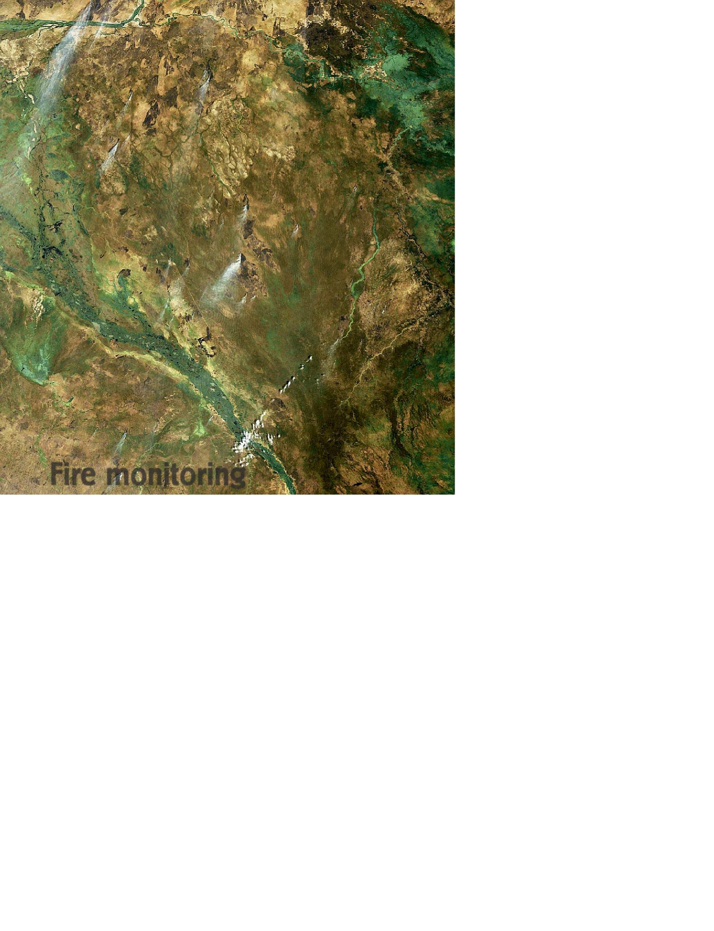
Smoke plumes from burning fires over South Sudan. Agricultural fires in the region are common during
the dry season beginning in November. The lush green area running from the top left to the bottom centre
of the image is the Sudd, one of Africa’s largest floodplains, providing watering and feeding grounds for
migratory fauna. Envisat/MERIS image
© ESA 2006
Fire monitoring
100 - Sustainable Development in Africa & Satellites


